

Blackberry Hills Journal · Munnar Travel
Munnar Road Trip: Scenic Routes, How to Reach & the Journey Between
From easy hill-road transfers to forest adventures and heritage stops, make the journey to Munnar part of your holiday.

Munnar is one of those destinations where the journey is part of the holiday. The last stretch into the high ranges brings winding roads, tea-covered slopes, waterfalls, changing weather and long valley views. If you are driving to Munnar, the best route depends on where you start, the season and how much time you want to spend on the road.
This guide explains how to reach Munnar by air, train, bus and car, including the final road transfer. It compares common approaches from Kochi, Bengaluru, Chennai, Coimbatore, Thiruvananthapuram and the Kerala backwaters, then explores scenic alternatives through Mamalakandam, Kallarkutty, Bison Valley, Chinnar, Marayoor and Malayattoor. Choose the route for your travel style, not just the shortest distance.
Plan your arrival with Blackberry Hills directions
Our team has compiled Google Maps driving routes for common starting points, with selected waypoints to help travellers find the approach to Blackberry Hills. Choose your departure point below to open the corresponding route in Google Maps.
Road trip to Munnar: the quick guide
| Starting point | Approx. road distance | Typical driving time | Common approach |
|---|---|---|---|
| Kochi | About 125 to 135 km | 4 to 5 hours | Perumbavoor, Kothamangalam, Adimali, Munnar |
| Bengaluru | About 470 to 500 km | 9 to 11 hours | Salem, Dindigul, Theni, Bodi, Munnar |
| Chennai | About 580 to 620 km | 11 to 13 hours | Trichy/Dindigul, Theni, Bodi, Munnar |
| Coimbatore | About 155 to 170 km | 4.5 to 6 hours | Pollachi, Udumalpet, Marayoor, Munnar |
| Alappuzha | About 160 to 180 km | 5 to 6 hours | Kottayam, Pala or Ettumanoor side, then the high ranges |
| Thiruvananthapuram (Trivandrum) | Roughly 280 to 310 km | Allow approximately 8 to 10 hours | Central Kerala via Kottayam or an alternative inland route, depending on current road conditions |
Swipe horizontally to view the complete route table on smaller screens.
All distances and times are approximate, measured to the Munnar area rather than a particular resort entrance. They vary with your exact starting point, route, traffic, stops, weather and road restrictions. Check a current navigation route before departure.
How to reach Munnar by flight, train, bus or car
Quick answer: Munnar is a hill station in Kerala’s Idukki district, reached by road for the final leg of the journey. It has no commercial airport or mainline railway station in the town itself. Most visitors arriving from farther away fly into Cochin International Airport or take a train to Aluva or Ernakulam, then continue by taxi or bus. If you are driving, the best route depends on your starting city and current conditions. Kerala Tourism’s Munnar access information and the Idukki district visitor guide are useful references.
Which is the nearest airport to Munnar?
Cochin International Airport (COK), near Nedumbassery, is the usual nearest major airport. Depending on where the journey is measured and which approach you use, official visitor guides place it roughly 105 to 120 km from Munnar. Plan on about four hours or more for the road transfer, allowing extra time for traffic, rain and the final hill climb. A prearranged taxi or private transfer is the simplest option with luggage. If you prefer public transport, check available connections towards Aluva or a suitable bus terminal and onward services to Munnar rather than assuming a direct airport bus at your arrival time.
How to reach Munnar by train: Aluva or Ernakulam?
There is no train station in Munnar town. Aluva (Alwaye) is a practical station for a shorter onward road journey, commonly described as approximately 105 to 120 km from Munnar. Ernakulam Junction and Ernakulam Town are useful alternatives with broader rail connections, though the onward drive is generally longer. Check where your train actually stops before booking a vehicle. From either station, continue to Munnar by road using a prearranged taxi or an available bus connection. Official sources differ slightly in stated distances because their reference points and routes differ.
Can you reach Munnar by bus?
Yes. Kerala State Road Transport Corporation (KSRTC) and other operators serve the Munnar area from regional transport hubs. A bus may be economical if you are travelling light and have time for connections. Check the current operating route, boarding point, availability and arrival time directly with the operator before relying on a connection, particularly for late arrivals or monsoon travel. Once in Munnar, allow for a separate local transfer to accommodation outside town, including the Pothamedu area. Public transport details are subject to change.
Taxi or bus: which is better for the final transfer?
Choose a taxi or prearranged transfer if you are arriving with substantial luggage, travelling with children or older family members, or reaching the airport or station late. A bus is generally more economical but may involve changes, waiting time and an additional local transfer. Compare the full door-to-door journey rather than only the fare to Munnar bus stand.
Thiruvananthapuram (Trivandrum) to Munnar: distance and route
How far is Munnar from Trivandrum? Plan for roughly 280 to 310 km by road, depending on the precise starting and finishing points and the route selected. Allow approximately eight to ten hours for a comfortable trip; road works, traffic, breaks and mountain weather can extend it. The distance from Thiruvananthapuram International Airport is not necessarily identical to the distance from the city centre.
A route through central Kerala and the Kottayam region is one approach; the best onward roads towards Munnar should be chosen using up-to-date navigation and local travel advice rather than a fixed turn-by-turn recommendation. For a long journey, leave in the morning so that the final climb can take place in daylight. If you are travelling by public transport, check whether a direct service is operating on your date or whether you need to connect through a larger bus hub.
Munnar distance and arrival questions
How far is Munnar from my location?
There is no single answer to “Munnar distance” without a starting point. Enter your actual departure location and Munnar town in a navigation app, then check the distance to your specific hotel as a separate final leg. Routes can differ substantially between a direct hill-road approach and a longer but more comfortable highway approach. The approximate distances in the table above are planning references, not live route calculations.
Which route is best to reach Munnar?
From Kochi or Cochin International Airport, the Kothamangalam and Adimali side is a common approach. From Coimbatore, a route through Pollachi, Udumalpet and Marayoor offers a different landscape. From southern Tamil Nadu, Theni and Bodi are commonly used approaches. The best choice is not always the shortest distance: seasonal restrictions, forest check-post rules, traffic and how comfortable you are with hill driving matter. Confirm the currently permitted route before setting off.
Can you travel directly from the airport or railway station to Blackberry Hills?
Yes, by a prearranged road transfer or private vehicle. Blackberry Hills is on the Pothamedu hillside outside the main Munnar town centre, so plan the transfer to the resort itself rather than assuming Munnar bus stand is the end of your journey. The estate has sloping paths and steps. Share your estimated arrival time and any mobility or luggage concerns with the reservations team in advance.
Kochi to Munnar road trip
For most visitors arriving by air or train, Kochi is the simplest starting point. The usual road climbs through Perumbavoor, Kothamangalam and Adimali before reaching Munnar. Once you enter the high ranges, the drive becomes slower and far more scenic.
Cheeyappara and Valara waterfalls are popular stops on this side of the route. In heavy rain, visibility and traffic can change quickly, so it is better to allow extra time rather than treating the drive as a fixed four-hour transfer.
Bengaluru to Munnar road trip
A Bengaluru to Munnar road trip is long enough to feel like a proper journey but still practical in a single day for experienced drivers. A common route runs through Salem and Dindigul towards Theni and Bodi before climbing into the Western Ghats.
If you are travelling as a family or prefer a relaxed pace, an overnight break can make the journey more comfortable. The final hill section deserves daylight if possible, especially if it is your first time driving in the region.
Chennai to Munnar road trip
From Chennai, the drive is substantially longer. Most routes work south-west towards Trichy or Dindigul and then continue through Theni and Bodi. Because the journey can easily take most of a day, leave early and avoid planning an aggressive sightseeing schedule for the evening you arrive.
The drive changes dramatically as you leave the plains and enter the mountains. Temperatures drop, roads narrow and the landscape becomes greener as you approach Munnar.
Coimbatore to Munnar via Marayoor
This is one of the most interesting approaches to Munnar. The route through Pollachi, Udumalpet and Marayoor passes through changing landscapes and enters Munnar from the north-east. Depending on conditions, the journey can include forest stretches and excellent views.
Do not rush this route. Wildlife movement, check-post procedures and hill-road traffic can slow the drive, and night driving is best avoided where possible.
Alappuzha to Munnar: from backwaters to mountains
Combining Alappuzha and Munnar gives travellers two very different Kerala landscapes in one trip. The drive generally moves inland through central Kerala before climbing towards the high ranges.
It is a useful route for travellers building a Kerala itinerary around the backwaters, Munnar and Kochi rather than treating Munnar as a standalone destination.
Scenic routes to Munnar: choose the journey that suits you
The fastest route on a map is not always the most memorable one. Some travellers want an easy transfer to their accommodation. Others would happily spend longer on a forest road, stop at a small jaggery-making unit or learn about a hydroelectric dam along the way. At Blackberry Hills, we encourage guests who are not pressed for time to think about the kind of journey they would enjoy before choosing a route.
How much extra time should you allow? Set aside at least two additional hours if you want to explore an alternative scenic approach, and considerably longer if you intend to visit a wildlife sanctuary, a heritage site or several attractions. That is an allowance for enjoying the journey, not a promise that any detour will take exactly two hours. Check the route, visiting hours, weather, road restrictions and your expected arrival time before departure.
Mamalakandam via Thattekkad: for adventurous drivers and nature lovers
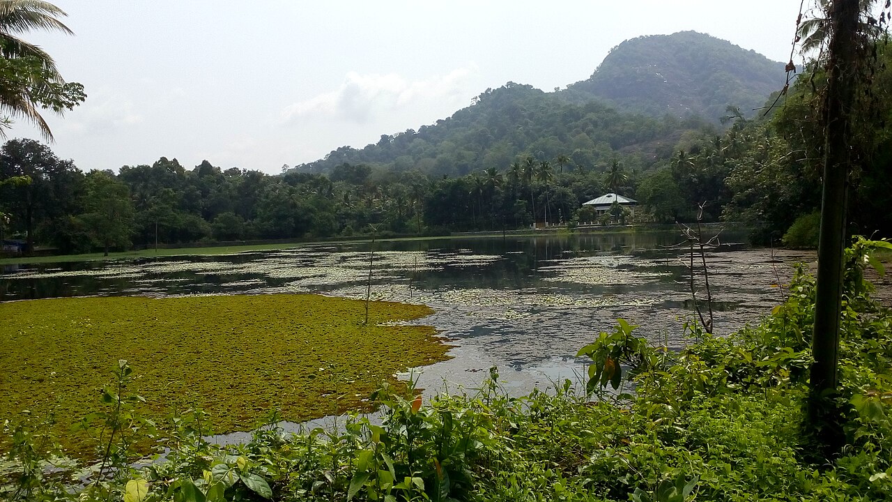
The experience: A slower approach through the Thattekkad and Kuttampuzha forest landscape towards Mamalakandam, with opportunities to see rivers, wooded hills, village life and, with luck, wildlife. Travellers from the Kochi and Kothamangalam side can investigate this alternative rather than automatically taking the main Adimali highway. The Dr. Salim Ali Bird Sanctuary at Thattekkad, a well-known birding destination near Kothamangalam, is a worthwhile potential stop if its visiting arrangements fit your day.
Our firsthand experience: The Mamalakandam forest approach can be narrow, rough and bumpy. Drive slowly and expect stretches where two vehicles may struggle to pass easily. Some local sections include small stream crossings. Although a normal car may negotiate a crossing when conditions are favourable, do not enter flowing or uncertain water, attempt a flooded crossing, or assume that a route remains suitable after rain. Verify the precise road and current access locally. Possible wildlife sightings are part of the appeal, but animals are never guaranteed and must never be approached, fed or disturbed.
Who should avoid it? We do not recommend this remote adventure option for elderly travellers or people with medical conditions that could require urgent assistance. Parts of the route can be far from medical facilities, and communications may be limited. It is also a poor choice for inexperienced hill-road drivers, after-dark travel, severe weather or anyone working to a tight arrival deadline. Forest access rules and check-post instructions always take precedence over an app’s suggested shortcut.
Kallarkutty and Bison Valley: reservoirs, hill scenery and a quieter arrival
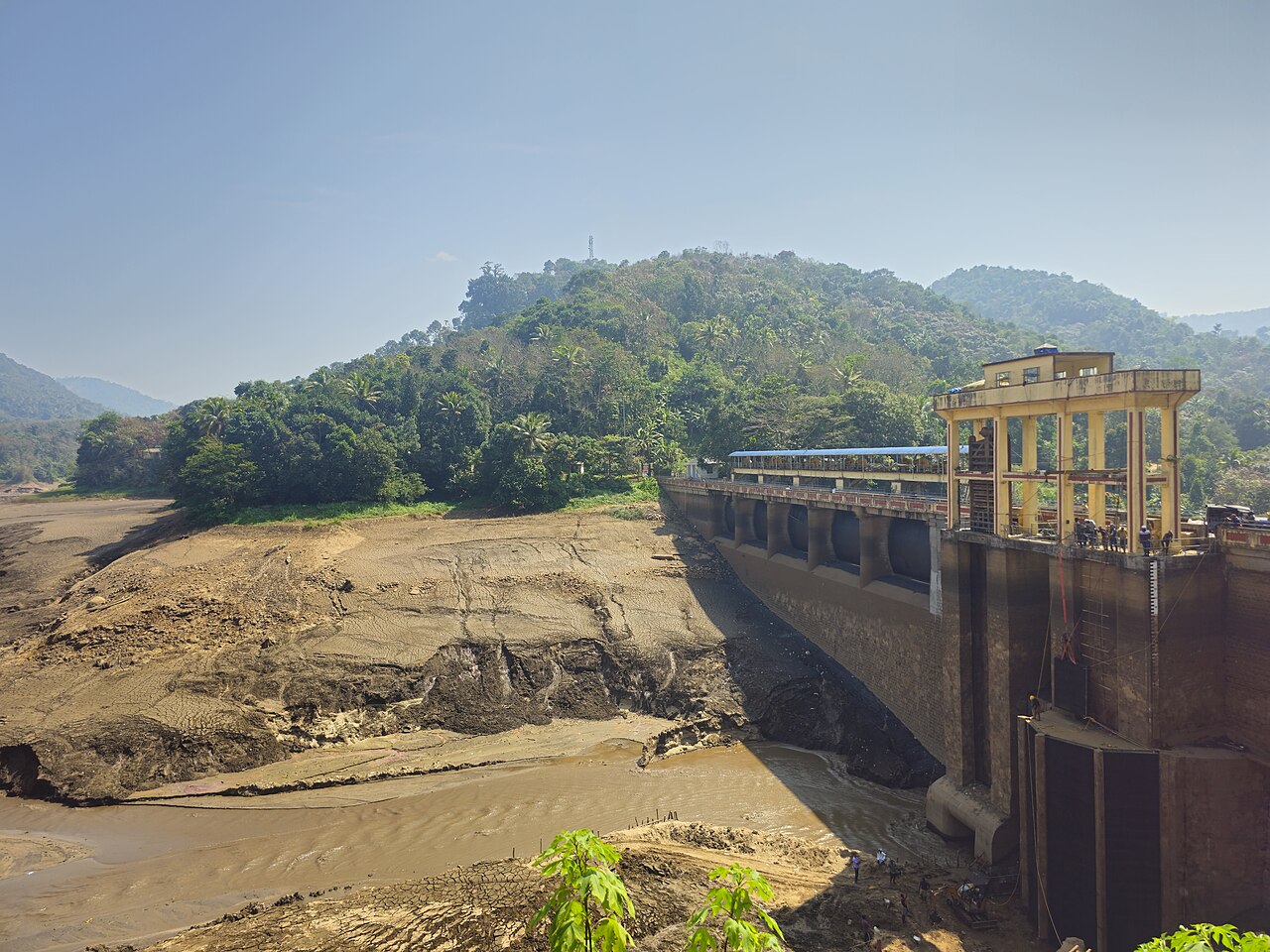
The experience: For travellers who prefer conventional roads but still want an interesting drive, the Kallarkutty approach offers water, greenery and a glimpse of the region’s hydroelectric history. The Kallarkutty Dam, on the Muthirapuzha River, forms part of the Neriamangalam Hydroelectric Project. Publicly accessible viewpoints may offer views of the dam and reservoir. The wider landscape includes KSEB hydroelectric infrastructure, but the powerhouse and operational dam areas are not automatically open to visitors. Observe them only from places where stopping and viewing are permitted.
Our firsthand experience: Compared with Mamalakandam, the Kallarkutty approach is generally a more straightforward drive on conventional roads. A connection onwards through the Bison Valley side can potentially bring guests towards Blackberry Hills without traversing the busiest parts of Munnar town. That may be worth considering during periods of heavy tourist traffic such as major festival holidays, although it is a longer route and not a guaranteed time-saver. Confirm the full driveable connection and current road conditions before setting out; temporary diversions, road works and restrictions can change the best option.
Best for: Travellers who enjoy scenery, rivers and engineering heritage, or who prefer an alternative to crowded town approaches without deliberately seeking a rough forest adventure. Never enter restricted KSEB areas or stop near spillways and water-release zones.
Chinnar and Marayoor: sandalwood country, traditional jaggery and ancient dolmens
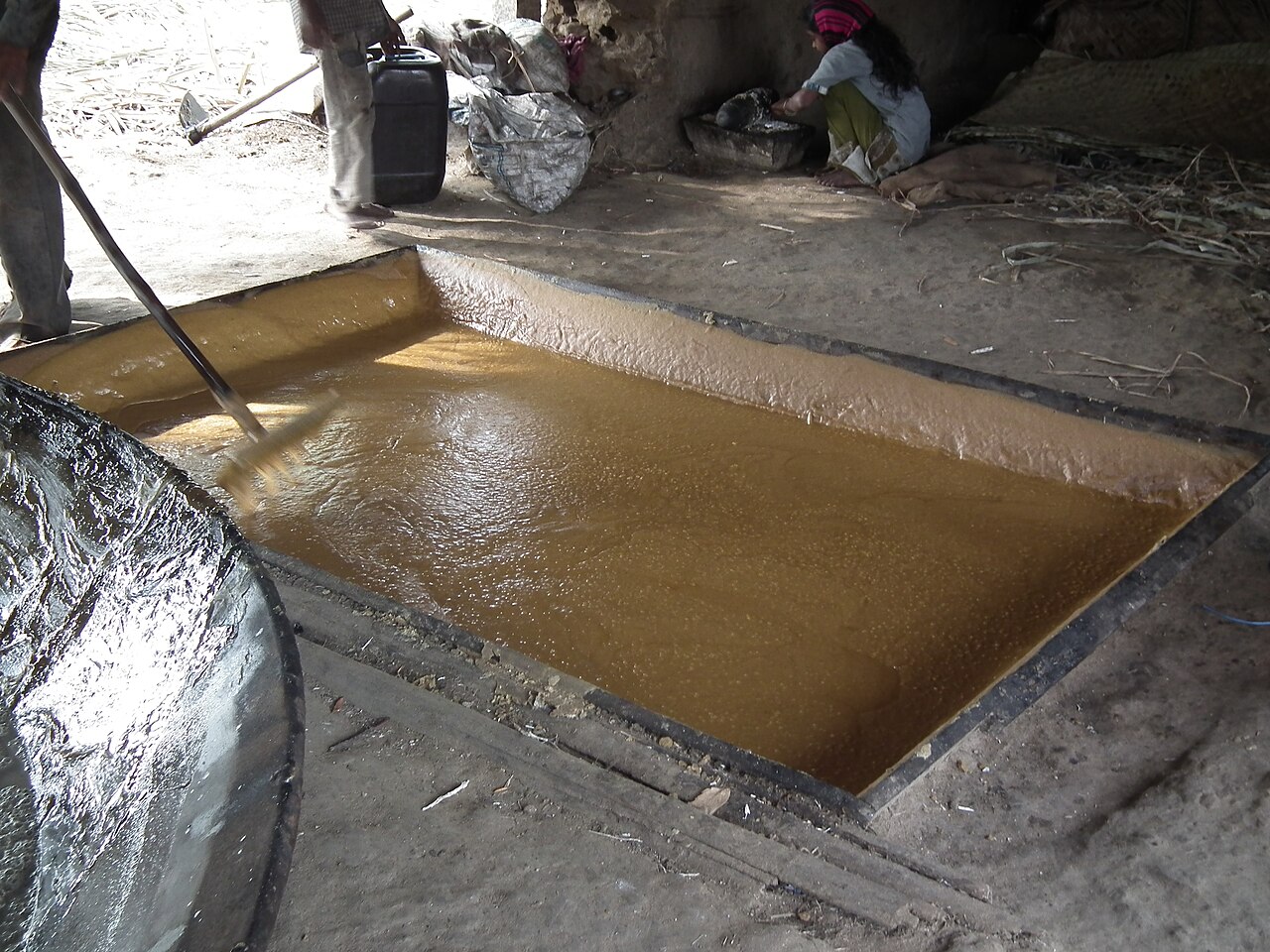
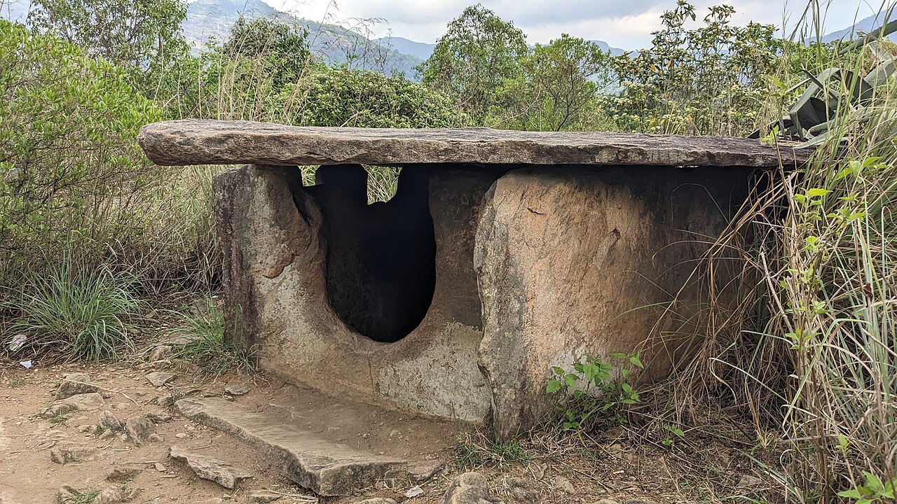
The experience: Guests approaching from Palakkad or parts of Tamil Nadu can consider the Chinnar and Marayoor side when the current road and forest-check-post conditions permit it. The landscape changes from the drier country near Chinnar to the sandalwood-growing region of Marayoor and the high tea-country roads closer to Munnar.
Two recommended stops in Marayoor: First, visit a local cottage-scale unit producing traditional Marayoor sarkara (jaggery), when a unit is operating and welcomes visitors. Second, make time for the ancient stone dolmens, locally called muniyaras, which give the journey a distinctive archaeological dimension. DTPC Idukki’s Marayoor guide identifies both experiences. Respect local workers, private property, archaeological sites and any visiting restrictions.
Consider Eravikulam National Park on the arrival day. The Rajamala visitor area is on the Munnar side of the Marayoor approach, so a preplanned visit may avoid returning along the same corridor from your resort. But the park is not a quick roadside stop: factor in parking, authorised park transport, entry arrangements and waiting time. Entry periods and seasonal closures can change; consult the official Eravikulam National Park website before scheduling your visit. It can be more efficient to explore attractions along your arrival route and enjoy a slower pace after check-in, as long as you reach the resort safely and without rushing.
From Thrissur: Mookkannur and Malayattoor for pilgrimage and an alternative approach
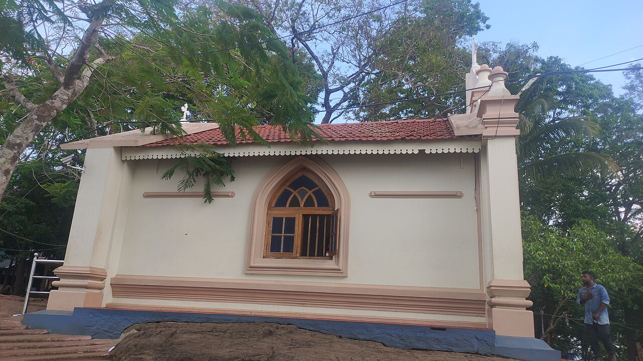
Travellers arriving from the Thrissur side can investigate an alternative via Mookkannur and Malayattoor rather than automatically following the busier Angamaly, Kalady and Perumbavoor corridor. The Malayattoor church and pilgrimage landscape can make this more than a traffic-avoidance detour for travellers interested in religious heritage.
Another potential stop in this wider region is Abhayaranyam at Kaprikkad near Kodanad, the wildlife rehabilitation and elephant-care destination associated with the former Kodanad elephant training centre. This is a separate stop to check on a route map, not a promise that every road through Malayattoor passes its entrance. Confirm current visitor access and hours before adding it to the itinerary. Detours via Mookkannur and Malayattoor may bypass some common bottlenecks, but actual time saved depends on live traffic and the onward road connection.
Explore en route, then settle in
Our preference is to visit attractions that naturally fit your arrival route before coming to Blackberry Hills. That may save a separate outing after check-in and leave more time to enjoy the resort. The principle is not to race through a sightseeing checklist: choose a few genuinely interesting stops, check whether they are open, allow generous buffers and prioritise arriving safely. When in doubt, a simple direct route is better than a rushed detour.
What the final drive into Munnar is actually like
The last part of almost every route is slower than the distance suggests. Expect bends, gradients, local buses, occasional road works, mist, rain and vehicles stopping at viewpoints. In good weather, this is also the most enjoyable part of the journey.
If you are prone to motion sickness, sit where you can look ahead, avoid a heavy meal immediately before the climb and keep water handy. Drivers should use lower gears on descents rather than relying continuously on the brakes.
Driving to Munnar during the monsoon
Munnar remains beautiful during the monsoon, but road conditions require more patience. Heavy rain can reduce visibility and minor slips or temporary traffic restrictions can occur in the high ranges. Avoid speeding, allow extra braking distance and check local conditions before setting out.
For a more detailed seasonal guide, read our guide to Munnar roads during the monsoon and our article on travelling safely to Munnar in the rainy season.
Road-trip planning tips
- Start early: daylight makes the mountain section easier and more enjoyable.
- Download offline maps: mobile coverage can weaken in isolated stretches.
- Refuel before the climb: do not wait until the last section of the journey.
- Check tyres, brakes and wipers: hill roads expose weaknesses quickly.
- Keep the itinerary flexible: traffic, mist and rain can change drive times.
- Avoid unnecessary night driving: unfamiliar mountain roads are more demanding after dark.
How many days should you spend in Munnar?
For a road trip, two nights is a practical minimum. It gives you one full day in Munnar without spending most of the holiday behind the wheel. Three nights is better if you want time for a trek, tea experiences, spa time or simply a slower day at the resort.
If you are planning a short stay, our 2-day Munnar itinerary is designed to keep driving and sightseeing realistic rather than packing every attraction into a rushed schedule.
Staying outside the busiest part of Munnar
After a long road trip, where you stay can change the feel of the visit. Blackberry Hills is in the Pothamedu and Pallivasal valley landscape, away from the densest part of Munnar town. The resort is spread across a 10-acre mountainside estate with independent cottages, valley views and nature-led experiences.
That makes it particularly suited to travellers who want the road trip to end somewhere that still feels connected to the mountains rather than returning immediately to town traffic.
Explore the stays at Blackberry Hills or check direct availability.
Before you set off: a note from Blackberry Hills
Drive safely. Wear your seat belt, and make sure everyone in the vehicle does too. Plan your route ahead of time, check your vehicle’s tyres, brakes, lights, fluids and wipers, and allow enough time for unexpected delays. Never push on through unsafe weather, a closed road or a difficult crossing merely to stay on schedule.
And leave room for discovery. A quiet forest stretch, a jaggery-making cottage, an ancient dolmen or a glimpse of a river may become the part of your Munnar holiday you remember most. Enjoy the journey. It is the journey that matters, not just the destination.